|
On the west coast, Porthleven is the
most southerly port in mainland Britain, a harbour full
of yachts and fishing boats. At Gunwalloe - Church Cove
you will find a beautiful church set amongst the sand
dunes. Mullion is a bustling little inland village
which has shops, inns, cafes and restaurants, craft
shops and art galleries, not forgetting the quaint
harbour at Mullion Cove. 
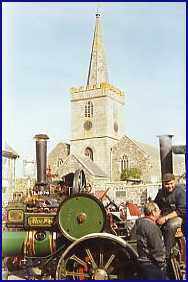
HELSTON - Gateway to The Lizard Peninsula
The bustling market town of Helston
lies midway between Falmouth and Penzance at the
junction of the A394 and A3083, which serves the Lizard
Peninsula to the south. Ideally located for exploring
South West Cornwall, Helston has plenty for visitors of
all ages. As you explore the town you'll see a mixture
of Georgian and Victorian architecture, one outstanding
feature being The Monument at the end of Coinagehall
Street, built in 1834 to the memory of Humphry Millet
Grylls. A Helston banker and solicitor, his actions
kept open the local tin mine, Wheal Vor, and saved 1200
jobs.
Walking up Coinagehall Street, you'll pass the Blue
Anchor, a thatched building, originally a monks' rest
house, which became a tavern in the 15th century.
Miners received their wages in the pub, which is
possibly the oldest private brewery in the country,
call in and enjoy the local brew, Spingo! Further up,
you'll find one of the oldest buildings in Helston, the
Angel Hotel, the former town house of the celebrated
Godolphins who represented Helston in Parliament for
many years.
A plaque on the wall of one Wendron Street cottage
marks the birthplace of Bob Fitzsimmons. Born in 1863,
he was the first man to be world middleweight, light
heavyweight and heavyweight boxing champion. He retired
in 1914 and died in Chicago three years later.
By the traffic lights is the imposing Guildhall. Over
the years this has been a market house and Magistrates'
Court; today it is the Town Hall with the Council
Chamber on the first floor. The ground floor is still
called the Corn Exchange and here you might be tempted
inside by coffee mornings, craft markets and jumble
sales. Behind the Guildhall you'll see a splendid
cannon taken from HMS Anson, wrecked at Lee Bar in
1807. This event, with its loss of life, inspired Henry
Trengrouse to invent the Breeches Buoy. The cannon
stands on guard outside the Helston Folk Museum, housed
in the old butter market, where you'll be fascinated by
the exhibitions of Helston's heritage.
Continuing along Church Street, you'll arrive at the
parish church of St Michael, dedicated to the patron
saint of Helston. It contains an impressive 24-branch
chandelier - a gift from the Earl of Godolphin in 1763
- and some fine Elizabethan brasses.
As you head out of Helston, past the Coronation Park
& Boating Lake, towards the fishing village of
Porthleven, you'll come to the parkland of the Penrose
Estate, which offers some beautiful woodland walks.
Here you can relax on the banks of the largest
freshwater lake in Cornwall, Loe Pool, separated from
the sea by a long sand bar.
Perhaps Helston's greatest claim to fame is the
internationally famous festival of the Furry, or Flora
Dance. This is held every year on May 8th unless that
day falls on a Sunday or Monday, when it is held on the
preceding Saturday.
You'll probably have to park outside the town and walk
in. Thousands of visitors throng the streets all day
and there's a carnival atmosphere from dawn to well
into the night.
You'll find the town decked out with bluebells, gorse,
laurel leaves and colourful flags. Dancing begins at
7.00 am, and at 8.30 there's the mummers'play known as
the Hal-an-Tow, at several venues throughout the town.
Watch St George and St Michael slay the Dragon and the
Devil, cheered on by a crowd dressed in Lincoln green
and Elizabethan robes.
The children of the town dance at 10.00 am, at midday
there's the principal dance, with invited participants
in top hats, tails and dress gowns; and a final dance
at 5.00 pm. The dancers weave in and out of the shops,
houses and gardens behind the Helston Band playing the
famous Flora Dance tune.
The origins of the dance are certainly pre-Christian
and are connected with ancient spring festivals all
over Europe. Nowadays its ancient intention of ushering
in prosperous harvests goes hand in hand with the
splash of colour all over the town, the joyous music
and high spirits of all involved.
PORTHLEVEN
Head west on the A394 from Helston to
Penzance and a left turn will bring you to Porthleven
the most southerly port in mainland Britain and an
excellent base for exploring South West Cornwall. A
harbour full of yachts and fishing boats, narrow
streets climbing the steep hillsides and spectacular
views, Porthleven has long been that happy Cornish mix
of fishing port and holiday resort. A happy mix of
working village and holiday centre, Porthleven offers a
variety of accommodation and you'll find restaurants,
pubs, galleries and gift shops trading alongside
fishmongers and chandlers.
The town was once a centre for boat building, its long
harbour wall protecting the port from the winter
south-westerlies which rage across Mount's Bay.
Nowadays, you'll find a welcome in the harbourside
cafés, restaurants and inns and enjoy time
browsing among the gift shops - you might even like to
buy some of the day's catch at the Quayside Fish
Centre. Porthleven's name is thought to come from the
old Cornish porth (harbour) and leven (level or
smooth), probably because the harbour was once a flat
marshland on the banks of a stream flowing into the sea
at a small cove. The stream still flows through the
valley and divides the village into the two parishes
Sithney to the east and Breage to the west.
By the 14th century, a hamlet of fishermen's dwellings
had established itself around the cove, separated from
the sea by a bar of shingle where the boats were kept.
This community continued to grow and by 1700 had been
joined by farmworkers and miners.
Then in 1811, to meet the demand for coal and supplies
for the nearby mines, together with the need for a safe
refuge for the fishing fleet, the construction of the
harbour began; the project was to take 14 years and the
workforce included many prisoners from the Napoleonic
wars. It was opened in August 1825 with a feast of
roast beef and plum pudding for the whole village.
In 1855 the harbour was leased by Harvey and Co., of
Hayle, who created a deeper inner basin which was
protected by the massive timber baulk gates still in
use today. Trade increased dramatically with imports of
coal, limestone and timber, and exports of tin, copper
and china clay. From the 1850's the Porthleven
boatbuilding industry became a major employer. The
large slip saw the launch of clippers, schooners and
yachts destined for ports around the world. Two
Porthleven-built trawlers still work from Brixham but
the last boat was launched from here in the late
1970's.
Much of Porthleven's daily routine is still played out
in the harbour, with houses and cottages cramming the
hillsides for the best view. Boats still fish from
here, the main catch being crab, lobster and
crayfish.
A few yards from the harbour you can soak up the sun
from the beach or take the South West Coast Path east
to the wild Lizard Peninsula or west to the spectacular
cliff-edge tin mines of Rinsey. Come in the summer and
you'll catch Porthleven in its holiday clothes, with
quayside concerts by the town band, gig racing and the
festival of St. Peter's Tide.
As you stroll round the harbour, you'll be passing
buildings which can tell a story or two of times past,
when the quayside heaved with activity. As you turn
into Breageside, the three storey building across to
your right was built in 1889 as fish-curing cellars
which turned thousands of hogsheads of pilchards for
export. The Wreck and Rescue Centre started life in
1893 as a china clay store; up to 7000 tons of china
clay from the Tregonning Hill quarries were kept here
prior to export. As you walk a little further on you'll
see a ruined turret-like building, once a lime-kiln,
built in 1814 to produce lime for the construction of
the harbour and the building boom which followed.
The two cannon either side of the harbour were once
fired in anger at Napoleon's navy during the battle of
Brest and come from the frigate HMS Anson, wrecked on
Loe Bar in 1807 with the loss of 120 sailors.
Just round from the Ship Inn is the old lifeboat
house, built in 1894. Porthleven had its own lifeboat
service from 1863 to 1929, which ran 28 missions and
saved 50 lives. The village retains strong links with
the RNLI and each August holds a colourful Lifeboat
Day. The Bickford-Smith Institute, with its imposing
70ft clock tower, was built in 1883 as a Literary
Institute by William Bickford-Smith of Trevarno. The
building featured in the national press in 1989, when
pictures showed the tower engulfed by enormous waves.
GUNWALLOE - Church Cove
|


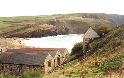 At Gunwalloe - Church Cove you will
find a beautiful church set amongst the sand dunes.
This little 15th century church of St Winwaloe, with
its tower built into the cliff, separate from the main
building, and usually half-buried in blown sand is said
to contain woodwork from the wreck of the 300-ton
Portuguese carrack San Antonio (St. Anthony). Captained
by Antonio Pacheco, she was wrecked on Saturday, 19 January,
1527, on the way from Lisbon to Antwerp with a cargo which
included copper and silver ingots.
At Gunwalloe - Church Cove you will
find a beautiful church set amongst the sand dunes.
This little 15th century church of St Winwaloe, with
its tower built into the cliff, separate from the main
building, and usually half-buried in blown sand is said
to contain woodwork from the wreck of the 300-ton
Portuguese carrack San Antonio (St. Anthony). Captained
by Antonio Pacheco, she was wrecked on Saturday, 19 January,
1527, on the way from Lisbon to Antwerp with a cargo which
included copper and silver ingots. The dramatic dishes of the famous
Satellite Earth Station dominate the Goonhilly Downs.
The largest operational satellite station on earth.
When viewed from afar, Arthur, Merlin and the other
dishes on Goonhilly Downs appear deceptively small.
Seen close up, they tower above you, silent monoliths
in almost reverent contemplation of the heavens. A
visit to BT's satellite earth station on Cornwall's
Lizard Peninsula is a truly awe-inspiring experience,
made even more so when you appreciate the story behind
Goonhilly. The dishes at Goonhill are busy sending and
receiving TV pictures all over the world, while
simultaneously handling thousands of international
phone, fax, data and video calls. When it opened in
1962, Goonhilly was one of the first 3 satellite earth
stations in the world. There are now over 200 satellite
earth stations scattered around the globe. Goonhilly,
with a total of 25 operational and development dishes,
is the worlds largest.
The dramatic dishes of the famous
Satellite Earth Station dominate the Goonhilly Downs.
The largest operational satellite station on earth.
When viewed from afar, Arthur, Merlin and the other
dishes on Goonhilly Downs appear deceptively small.
Seen close up, they tower above you, silent monoliths
in almost reverent contemplation of the heavens. A
visit to BT's satellite earth station on Cornwall's
Lizard Peninsula is a truly awe-inspiring experience,
made even more so when you appreciate the story behind
Goonhilly. The dishes at Goonhill are busy sending and
receiving TV pictures all over the world, while
simultaneously handling thousands of international
phone, fax, data and video calls. When it opened in
1962, Goonhilly was one of the first 3 satellite earth
stations in the world. There are now over 200 satellite
earth stations scattered around the globe. Goonhilly,
with a total of 25 operational and development dishes,
is the worlds largest. The Lizard Peninsula is one of the
few places where the rock Serpentine can be found, when
it is polished or wet, it resembles the skin of a
snake. At Lizard village and on the point, the
serpentine turners can be seen polishing and making
objects from this unusual stone.
The Lizard lighthouse
is mainland Britain's most southerley lighthouse, first
built in 1751; in the summer months it offers guided
tours where you can visit the engine room and the top
of the lighthouse.
The Lizard Peninsula is one of the
few places where the rock Serpentine can be found, when
it is polished or wet, it resembles the skin of a
snake. At Lizard village and on the point, the
serpentine turners can be seen polishing and making
objects from this unusual stone.
The Lizard lighthouse
is mainland Britain's most southerley lighthouse, first
built in 1751; in the summer months it offers guided
tours where you can visit the engine room and the top
of the lighthouse.